University of California Berkley
Berkeley Seismology Laboratory
Ronni Grapenthin
Sendai 2011-Mar-11, 05:46:23 UTC Earthquake: Kinematic GPS solutions -- will be updated as new results are processed. (Last modified: April 03 2012 23:46 AKST)
Paper, Presentations
Sep. 23, 2011: Our paper on this work has now been published in GRL: The dynamics
of a seismic wave field: Animation and analysis of kinematic GPS data recorded during the 2011 Tohoku-oki earthquake, Japan (GRL Editors' Highlight).
High resolution version of the figures are here: Fig. 1, Fig. 2, Fig. 3
The final versions of the animations can be found here: Movie 1, Movie 2, Movie 3
Tohoku-oki Earthquake animation featured in National Geographic Video.
Here is a presentation giving a short summary of some of the findings below intended for outreach purposes.
Movie of an earthquake (and another) -- Difference in order of magnitude visualized.
I created higher quality movies than the ones published on YouTube. Since those are currently being considered for publication I haven't posted them yet. Send me an email, if you want to have access to those for teaching/outreach purposes.
|
Cumulative displacements, 1Hz solutions by GPS Solutions
based on real time products (note that the earthquake shows up 15s too early as I did not convert GPS time to
UTC time in this version. It will be fixed soon): http://rtgps.com/rtnet_dl_eq.php
(download mp4) |
|
|
Cumulative displacements (download avi) |
|
|
M9.0 co-seismic removed from 05:55:30 UTC onwards by subtracting 05:55:00 displacement field (download avi) |
The movie shows the displacements as well as body and surface waves created by the M9.0 and M7.9 earthquakes in Japan on March 11, 2011 between 05:30-06:30 UTC. Each dot/arrow represents a continuous high precision GPS station of which more than 1200 are distributed throughout Japan in a network called GEONET. This is an absolutely unique instrumentation density found nowhere else on the world. I visualize and postprocess the 30 second positioning solution provided by the ARIA team ("Preliminary GPS time series provided by the ARIA team at JPL and Caltech. All original GEONET RINEX data provided to Caltech by the Geospatial Information Authority (GSI) of Japan.").
The blue vectors show horizontal displacements, meaning that the direction of the vector on the plot actually points in the direction of motion/displacement. The red vectors show vertical displacement; which is either up or down from the GPS site's initial position as indicated by the arrow head. The base of all arrows denotes the location of the GPS site. All displacements shown are with respect to the first measurement of the UTC day 2011-March-11.
What you see is both dynamic displacement and static displacement and what the difference between an order of magnitude for an earthquake means in terms of energy release and affected region. The dynamic displacement is composed of at least three components (very preliminary, visual analysis):
- the actual slip of the M9.0 earthquake occuring at least in frames 05:47:30-05:49:00,
- a wave inducing small displacements that travels at about 8.6 +/- x km/s (likely: Body wave, apparent velocity),
- a wave inducing large displacements that travels at about 4.8 +/- x km/s (likely: Surface wave).
Captured wave ... (Click images below for high-res version)
I visualized these data: "Preliminary GPS time series provided by the ARIA team at JPL and Caltech. " to create the figures/videos below. You can download the data here. First we have an animated gif for the whole day (Here is a movie in avi format, mpeg4 encoded):
Second, we have a really cool observation, a captured wave (2nd and 4th panel):
The data I used are the 5 minute solutions provided by ARIA/JPL/Caltech. I show displacements with respect to the first position calculated that day for each station. UTC time is given in the lower right corner. The center panel clearly captures the surface wave in the Tokio and southern Hokkaido region. It's going concentrically outwards from the main shock and visible in both the vertical and horizontal fields, though a little more obvious in the horizontal. The vertical clearly changes sign. The lower panel shows the permanent displacements after the main shock. Carl Tape alerted me to tickle out the dynamic feature so I subtracted panel 3 from panel 2 to get the lower panel. Thanks.
Below here we processed publicly available data. I present two sets of plots:
1) kinematic solutions for 05:30-06:30 UTC of 11-March-2011 and
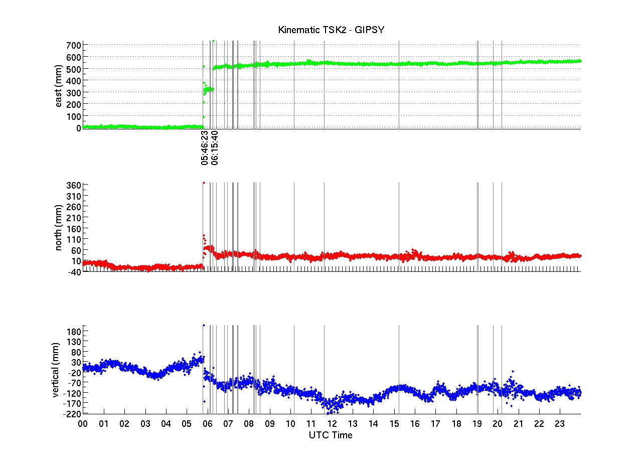
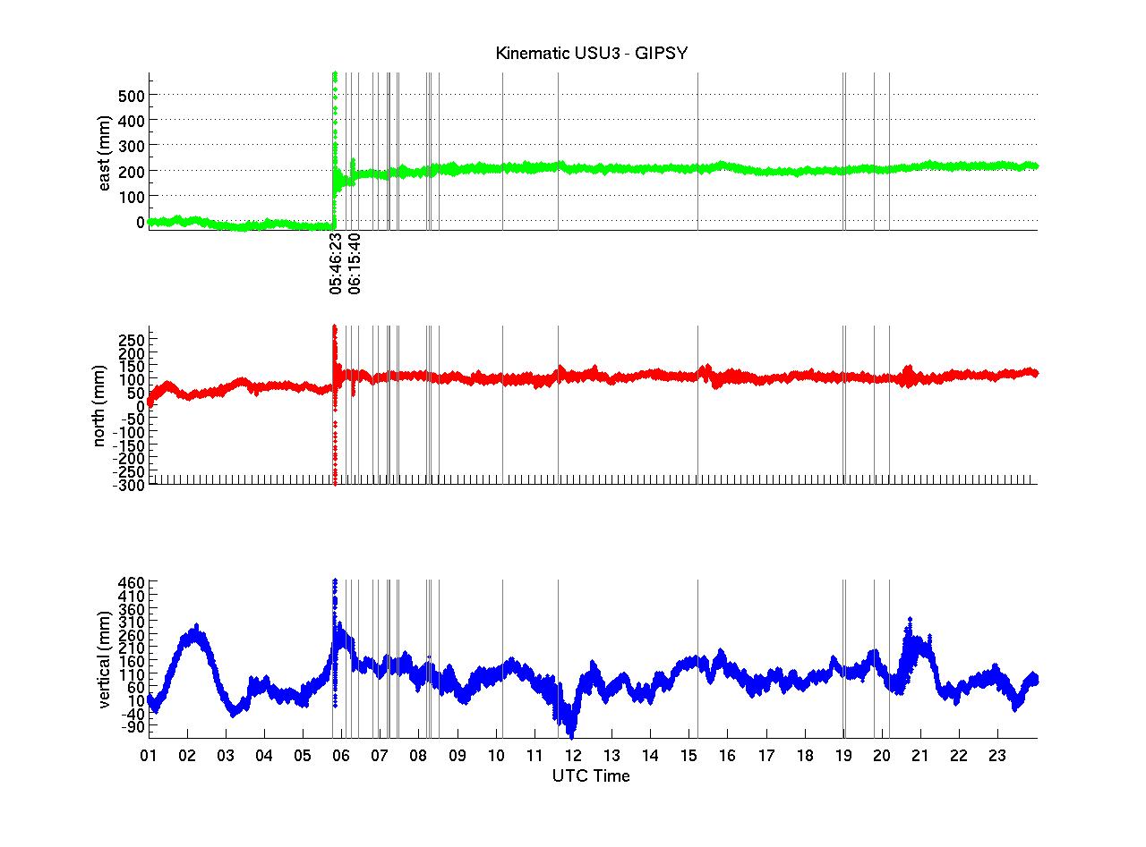
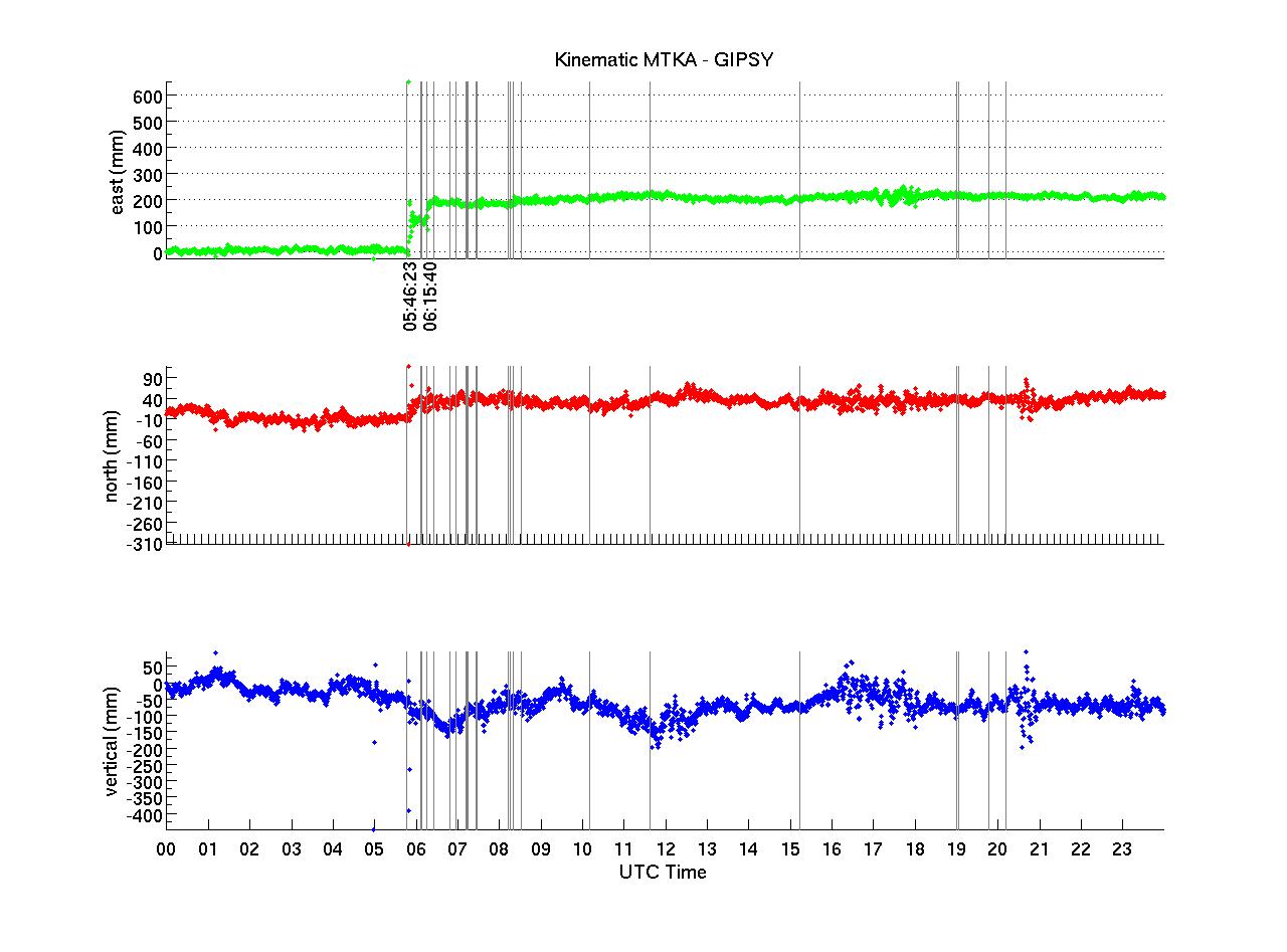
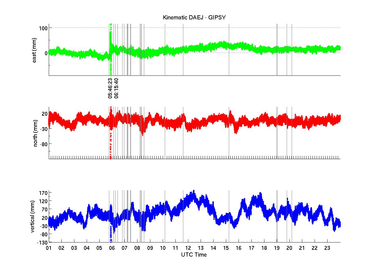
2) kinematic solutions for the entire day (11-March-2011)
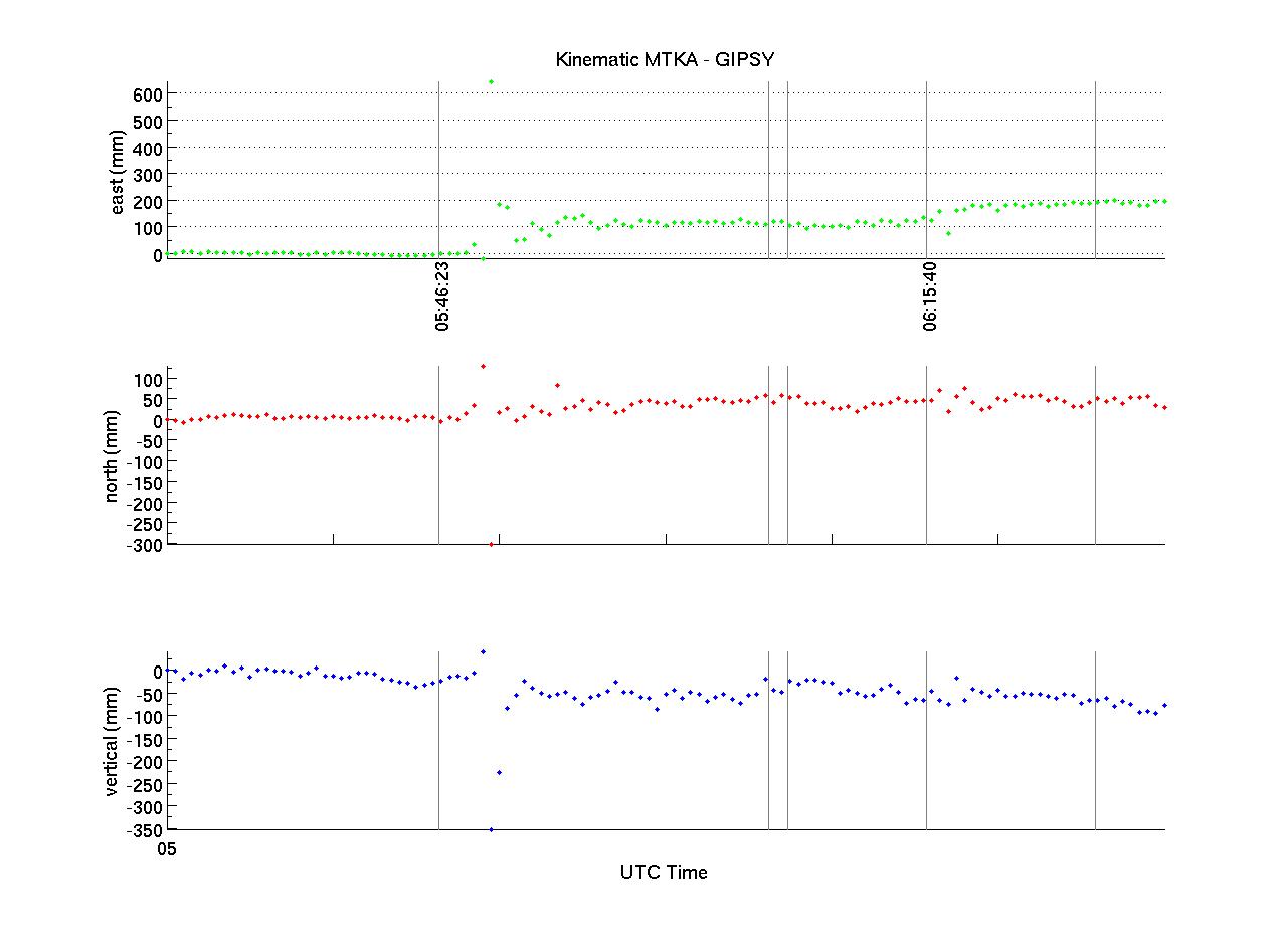
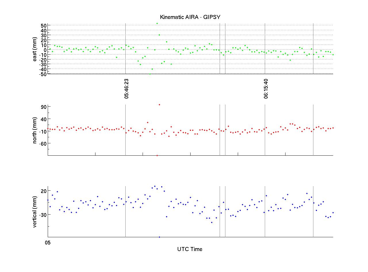
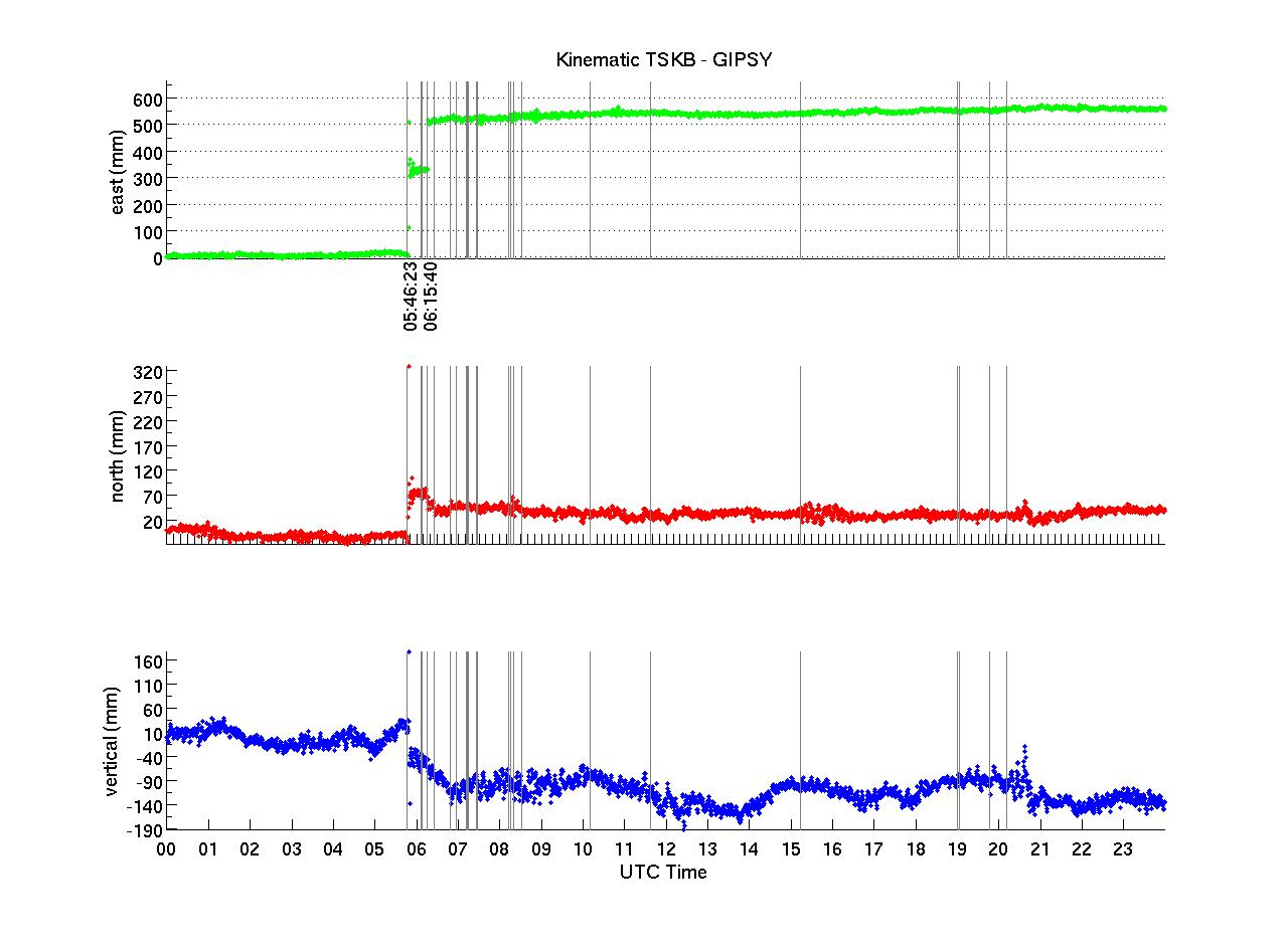
for GPS stations AIRA, DAEJ, MIZU, MTKA, TSKB, TSK2, USU3 (which is IGS site USUD) (see map above).
DAEJ, MIZU, USU3 record 1Hz data. AIRA, MTKA, TSKB and TSK2 record 30 second data (no high rate available). The high rate data was downloaded from CDDIS. We use JPL's rapid orbits for our solutions which are computed using JPL's GIPSY/OASIS in kinematic mode. We remove an ocean load model (tpxo7, computed using spotl) during processing.
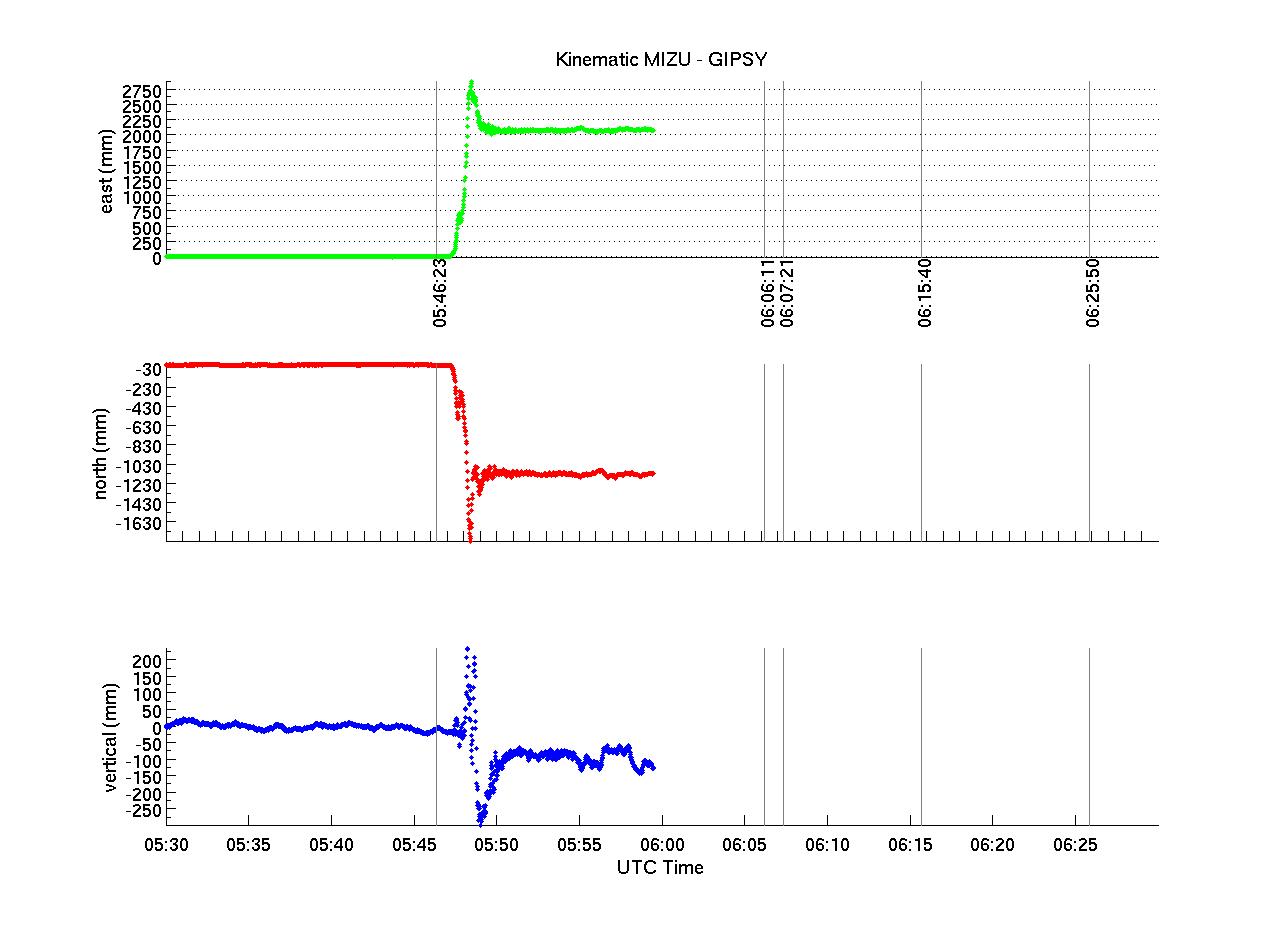
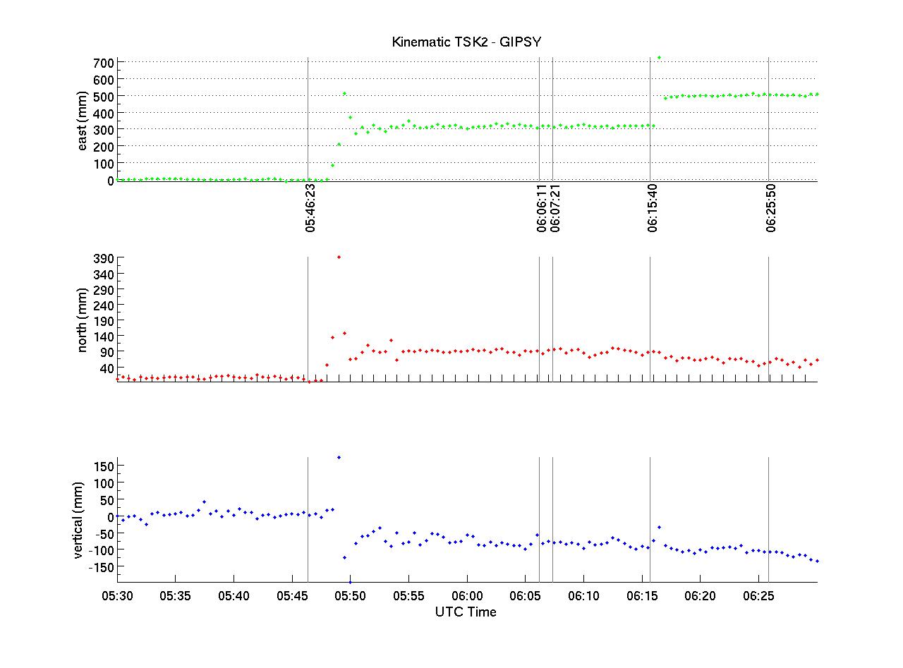
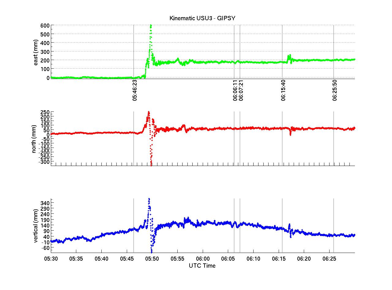
The figures themselves contain three panels: east, north, and vertical displacements in mm. The gray vertical bars denote earthquakes with magnitude >= 6.0 that occurred in the Honshu region after the main shock at 5:46:23 UTC (from USGS). On the horizontal axis, the upper panel shows the times of the earthquakes, the middle panel shows minute / 10 minute tick marks, the lower panel gives 5min / 1hr intervals.
We find two major responses in the presented time series:
1) displacements (permanent/surface waves) to the main shock, and
2) to the earthquake at 6:15:40 which in preliminary results is listed as a 6.8 slightly offshore East of TSKB/TSK2.
Displacements to (1) are clearly visible at all sites. Displacements to (2) do only show up at TSKB/TSK2, USU3. No data is available for MIZU at this time. No significant displacements are visible at DAEJ.
The long wavelength features in the vertical component of USU3 during the time of the earthquake does not seem to be related to the event since the full day solution shows multiple such excursions. Only processing of additional days will allow for an interpretation of this signal. However, I want to draw your attention to the vertical signal for stations TSKB/TSK2 which are nearly co-located (~40 m apart). The signals appear rather similar for these two sites mainly with a strong subsidence signal after the earthquake (about 18-20cm peak to peak). Due to the different geometry at these sites and the amplitude of the signal, this is unlikely to be a multi path effect and might be due to a long wavelength loading signal. Which due to the nature of load displacements is unlikely to be visible in the horizontal. We speculate this to be due to changes in ocean load (tsunami).
We provide you with the displacements to both earthquakes at sites DAEJ, MTKA, MIZU, TSK2, TSKB, USU3 (USUD) (see map):
	# UTC       STA       dE         dN         dU  (all in mm)
	05:46:23    AIRA      --         --         --	       #AIRA shows no / very small permanent displacements
	06:15:40    AIRA      --         --         --         #that are hard to reliably quantify in 30s solution.
	05:46:23    DAEJ     26.2        4.1      -36.2
	06:15:40    DAEJ    -10.9        8.3       15.8
	05:46:23    MTKA    110.3       40.4      -41.0
	06:15:40    MTKA     73.2        2.2      -21.2
	05:46:23    TSK2    320.2       84.9      -86.4
	06:15:40    TSK2    183.1      -32.2      -25.4
	05:46:23    TSKB    313.3       83.5      -73.9
	06:15:40    TSKB    185.0      -29.5      -25.0
	05:46:23    USU3    178.6       52.2      137.3
	06:15:40    USU3     23.3       -0.2      -98.9
	05:46:23    MIZU   2000.0    -1200.0     -100.0		#visual from figure
	# compare vertical to time series to evaluate significance!!
The offsets are calculated by averaging the positions from
05:30-05:40 and 06:00-06:10 UTC for the Sendai 8.9 Earthquake
06:00-06:10 and 06:20-06:30 UTC for the 6.8 06:15:40 Earthquake
The pre-earthquake average position is then subtracted from the post-earthquake average position. Times are the times of the respective earthquake causing the
displacement for identification; not the times of the actual displacements at the site. The latter would be insignificant for a 30s solution and the precision for
1Hz solutions is considered to be low compared to travel times. Offsets at MIZU for the main shock are estimated from the figure (will be refined later).
Waveforms (Click on the image to enlarge)
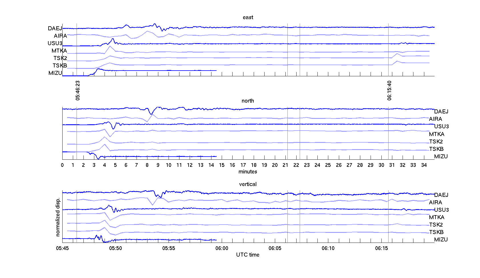
Figure shows wavefront propagation through a small subset of continuous GPS stations MIZU, TSKB, TSK2, MTKA, USU3, AIRA, DAEJ in east, north and vertical components (see map for positions). The respective displacements have been normalized between [0,1]. Position measurements have been connected in a continuous line for better visibility; note that 30 sec stations are indented and plotted in light blue. Vertical gray bars denote earthquakes M>=6.0 with origin time given for the two displacement inducing earthquakes. Seismic waves arrive at the closest site MIZU approx. 1 min after the first earthquake (distance approx. 135 km). The most distant site processed, DAEJ, shows signs of surface waves about 5:40 (S-wave?) and 7:20 min (Surface wave) after the earthquake (distance approx. 1340 km). This puts the travel time for the surface waves somewhere between 2-3 km/s. Displacements due to the second earthquakes are visible, but travel time for TSK2 and TSKB is hardly significant since it is 30 second data. The surface wave for this quake arrives at USU3 approx. 1 minute after the event (distance approx 250 km). Note that distances are subject to change pending final locations of the earthquakes.
Similar figure as above, but shows data for the entire day. An interesting blip at MTKA a little before 05:00 UTC and nice correlation in North and Vertical components a little after 20:20 UTC.
First Permanent Displacements (Click on the image to enlarge)
Map shows permanent horizontal displacements as presented in table above. Red scale bars show similar scale, but different lengths for displacements in upper panel which are induced by the main earthquale. The blue scale bar refers to displacements in the lower panel which shows displacements due to the 6:15:40 UTC earthquake. Note that TSK2 and TSKB are plotted on top of each other since they are practically co-located. I included both to present consistent processing results. Note opposite sense of direction for DAEJ for the two events.
Solutions for 05:30:00-6:30:00 UTC (Click on the images to enlarge)
|
 |
|
 |
|
 |
 |
Solutions for the entire day (2011-03-11) (Click on the images to enlarge)
Click on the images to enlarge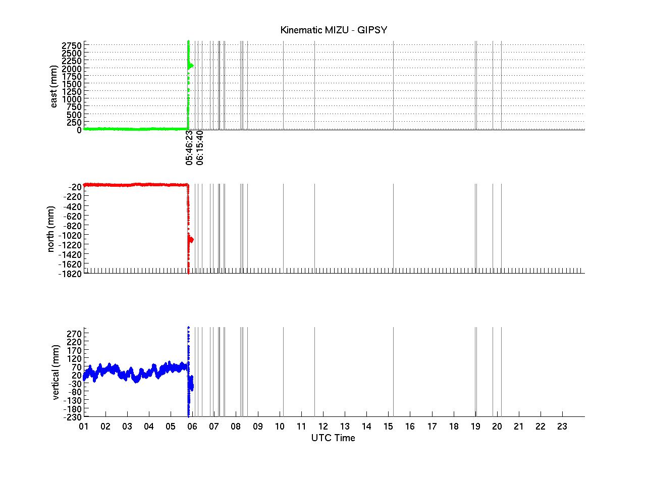
|
 |
|
 |
|
 |
 |
ronni <at> gi <dot> alaska <dot> edu | Last modified: April 03 2012 23:46.


