


As part of the Alaska Volcano Observatory (AVO), we carry out monitoring and research of the deformation of volcanoes in Alaska. Our work thus combines pure and applied research, and students working with AVO gain the experience of working in a volcano observatory as part of their graduate studies. AVO is a tripartite collaboration between the US Geological Survey, University of Alaska Fairbanks, and Alaska Division of Geological and Geophysical Surveys (the State Geological Survey).
AVO has continuous GPS networks on Okmok and Spurr volcanoes in the Aleutian arc, and 4 stations on Akutan that complement the Plate Boundary Observatory (PBO) network there. We have estbalished temporary continuous GPS networks on Okmok and Redoubt volcanoes, in response to their recent eruptions. In addtion, PBO maintains networks on Augustine and Akutan, and a network on Unimak Island that covers Westdahl and Shishaldin volcanoes. AVO plans to modernize and upgrade its monitoring networks at several high threat volcanoes, and this will include the addition of continuous GPS instruments at monitoring sites on those volcanoes. Within the next 2 years, we plan to upgrade or install GPS sites at Redoubt, Spurr, Okmok and Akutan. The new AVO GPS sites will be built to or similar to PBO standards. Makushin volcano next to the important fishing port of Dutch Harbor is another high threat volcano that will need network upgrades as resources permit.
There have been several significant events captured using AVO GPS and other geodetic data:
| 1997 | Eruption of Okmok volcano |
| 1998-2001 | Inflation of Westdahl volcano |
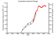
| 1997-2005 | Rapid inflation of Okmok volcano |
| 2004 | Unrest at Spurr volcano |
| 2006 | Eruption of Augustine volcano |
| 2008 | Eruption of Okmok volcano |
| 2009 | Eruption of Redoubt volcano |
2009 Eruption of Redoubt
The eruption of Redoubt began in March 23, 2009, after a few months of increasing unrest. The eruption was preceded by only subtle deformation. Once the eruption began, we observed deep deflation from the PBO site AC17, located 27 km ENE of Redoubt, and also from more proximal temporary continuous sites deployed by AVO. One site was established with real-time telemetry in March, but the instrument was hit by lightning in the first few hours of the eruption and destroyed. It was eventually restored several weeks later. Three temporary continuous sites were deployed, without telemetry, and have been downloaded by AVO personnel as field operations permitted. One of these sites will be converted to real-time telemetry as soon as it is safe to do so.
As of this writing (May 5, 2009), the geodetic signals from the Redoubt GPS sites have been complex and not simple to interpret. In large part this is due to the small number of stations. So far, we observe a deep deflation source, which we think is at true mid-crustal depths (10-15 km). This source was activated once extrusion began, and is most prominent in data from far-field sites. In addition, the data from near-field sites require a shallower source with a more complex time history. This is evident because the near-field stations show a different time hstory than the far-field sites.
Dr. Jeffrey T. Freymueller
Professor of Geophysics
Geophysical Institute
University of Alaska, Fairbanks
Fairbanks, AK 99775-7320